
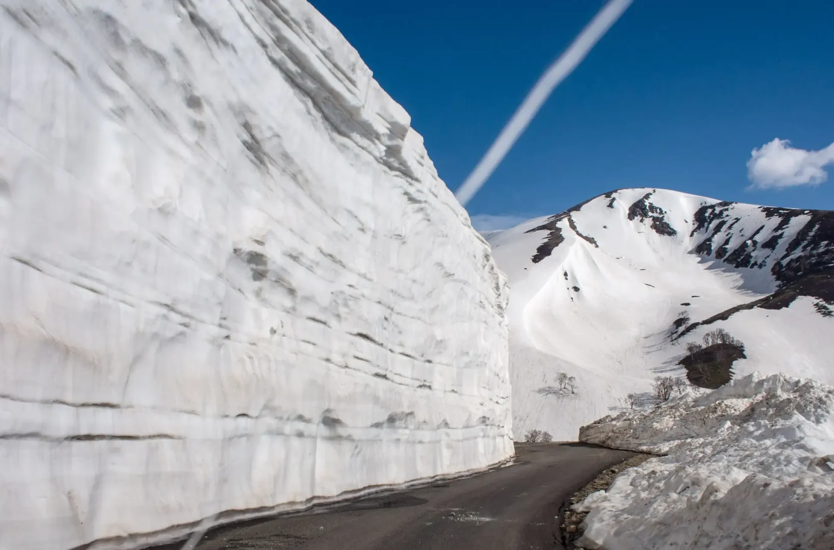
If you’ve already ticked off Gulmarg, Pahalgam and Sonmarg and you’re wondering what’s left to see in the valley, Sinthan Top Kashmir is probably the answer nobody’s told you about yet. This high-altitude mountain pass in South Kashmir sits right on the edge of the Pir Panjal range, at the point where the Kashmir valley quietly hands over to the Kishtwar region of Jammu. There’s no queue for a gondola ticket here and no souvenir stalls lined up along the road — just a long, winding drive that keeps climbing until the trees thin out and the mountains take over completely.
This guide covers everything you actually need before making the drive: how far it is, when to go, how to get there safely, what to do once you’re up there, and where to stay nearby.
Where Is Sinthan Top Kashmir? Location, Altitude & Quick Facts
Sinthan Top Kashmir sits in the Pir Panjal mountain range, right where the Anantnag district of Kashmir meets the Kishtwar district of Jammu. Technically, most of the pass lies on the Kishtwar side, though almost everyone visits it from the Kashmir valley, driving up through Anantnag and Kokernag. It isn’t a village or a town — there’s no permanent population up here, just shepherds who camp with their herds through the summer and the odd tea stall that opens for a few months a year.
The pass sits at roughly 3,800 metres (about 12,500 feet) above sea level, which makes it one of the higher motorable points anywhere in the region. It runs along NH 244, the road connecting Anantnag to Kishtwar via Kokernag, and it’s also the only road link between the remote Warwan and Marwah areas of Kishtwar and their own district headquarters. That’s worth remembering — this pass matters to the people who actually live on either side of it, not just to tourists chasing a view, a detail the Kishtwar district administration’s own tourism page backs up with local route details.
A quick snapshot before you plan your Sinthan Top Kashmir trip:
- Altitude: ~3,800 m / 12,500 ft
- Location: Border of Kishtwar and Anantnag districts, Pir Panjal range, Jammu & Kashmir
- Distance from Srinagar: ~130 km (4–5 hours by road)
- Distance from Anantnag: ~73 km
- Distance from Kokernag: ~48 km
- Distance from Daksum: ~35 km
- Distance from Kishtwar town: ~80 km
- Nearest airport: Srinagar (~135 km)
- Best time to visit: June to early October
- Mobile network: None at the top
- Entry fee: None (a vehicle toll may apply on the Anantnag–Kishtwar road)
How to Reach Sinthan Top Kashmir from Srinagar
By Road via Anantnag – Kokernag – Daksum
Reaching Sinthan Top is a scenic 4 to 5-hour drive from Srinagar via Anantnag and Kokernag. Daksum serves as the last reliable stop for fuel, food, and mobile network before the final 35 km ascent, which features steep switchbacks and narrow mountain roads requiring an experienced driver..
By Air
The nearest airport is Srinagar International Airport, about 135 km away. If you’re flying in from outside Jammu and Kashmir, you’ll land here first and then continue by road — there’s no shortcut around that last stretch.
Taxi & Self-Drive
Shared taxis run reliably between Srinagar, Anantnag and Kokernag, but once you’re past Daksum, shared transport gets patchy, and you’re better off with a private cab or your own vehicle. If mountain driving isn’t something you’re confident with — sharp turns, missing guardrails in places, occasional loose gravel — hire a local driver who’s done this route before. This isn’t a road worth learning on. If you’d rather have someone else handle the logistics end-to-end, our Srinagar-based team can arrange a driver who already knows this route.
Best Time to Visit Sinthan Top Kashmir
June to August: This is when Sinthan Top Kashmir looks its best — meadows are green, wildflowers are out, and the road is fully open. Days are pleasant, but it still gets cold once the sun dips, so a jacket is non-negotiable even at the height of summer.
September to Early October: Fewer travellers, clearer skies, and the first hints of autumn colour lower down in the valley. If you’d rather not share the viewpoint with a dozen other cars, this window is worth prioritising — it’s a season we cover in more detail in our guide to autumn in Kashmir.
November to May: This is when Sinthan Top Kashmir mostly disappears from the itinerary. Heavy snowfall closes the road, and while the upper reaches stay under snow for much of the year, that doesn’t mean the pass is set up for winter tourism the way Gulmarg is. A few blogs describe skiing here through December and January — in practice, the road is usually shut by then, and there’s no lift infrastructure or ski patrol up here, so treat any “winter skiing” claim with some caution.
If proper snow sports are the goal, our guide on planning a winter ski trip to Gulmarg is the safer, better-equipped choice. If you just want to see Kashmir under snow generally, our month-by-month guide to the best time to visit Kashmir for snowfall breaks that down properly.
Things to Do at Sinthan Top Kashmir
Trekking to the alpine lakes. Sinthan Top Kashmir isn’t just a viewpoint — it works as a base camp for some of Kashmir’s more remote alpine lakes and trails through the surrounding Pir Panjal ridges. Most of these routes need a local guide and some planning, so if high-altitude trekking is genuinely your thing, it’s worth reading our guide to unexplored alpine lake trekking routes in Kashmir before committing to one.
Photography and wildflower meadows. Between June and August, the slopes here fill with wildflowers, and the light here — especially early morning and just before sunset — is dramatically different from what you’ll get in the more crowded parts of the valley. Bring a wide-angle lens if you have one; the scale of these mountains doesn’t come through well on a phone camera alone.
Camping and stargazing. There’s no formal campsite, but with almost no light pollution, camping near the pass under a clear summer sky is one of the better stargazing experiences in the region. It’s not something to attempt solo — team up with a local operator or a group who know the area.
Short hikes and picnics. If you’re travelling with family or aren’t up for a full trek, the meadows around the pass are ideal for a slow walk and a picnic lunch, with views that don’t ask for much physical effort in return.
What to Expect at Sinthan Top
Sinthan Top is not a developed tourist attraction with hotels, restaurants or organised activities at the summit. The experience is mainly about the mountain drive, open alpine landscape and panoramic views once you reach the top.
On a clear day, you can expect:
- Wide views across the surrounding Pir Panjal mountains
- Open alpine slopes and meadows below the summit
- Snow patches during parts of the summer season
- Cold and windy conditions, even when lower areas are warm
- Very limited facilities at the top
Don’t depend on finding reliable food, fuel, toilets or mobile connectivity at the summit. It is best to eat, refuel and complete essential preparations before leaving the lower areas around Kokernag and Daksum.
The weather is also a major part of the experience. A clear view is never guaranteed, and clouds or fog can move in quickly at this altitude. For the best chance of enjoying the views, start early and try to reach the higher stretches before afternoon weather changes.
Nearby Places to Combine With Sinthan Top Kashmir
Daksum. About 35 km before the top, Daksum is a forested little town that makes a good overnight base if you’d rather not do the whole Srinagar–Sinthan Top–Srinagar drive in a single day. It’s calmer, greener, and easier to reach than the pass itself.
Kokernag. Around 48 km from the pass, Kokernag is known for its gardens and trout hatchery, and it sits naturally on the route up or down.
Kishtwar (Jammu side). For travellers doing a longer Kashmir-to-Jammu circuit, continuing past Sinthan Top Kashmir into Kishtwar opens up a genuinely different, far less touristy side of the region. It’s not a casual detour — it needs planning and local knowledge of road conditions — but it’s a rewarding route for anyone who’s already covered the standard Kashmir circuit.
If South Kashmir’s offbeat side is what you’re chasing, It pairs naturally with two of our other guides: Doodhpathri, Kashmir’s “Valley of Milk,” and Aharbal Waterfall, often called Kashmir’s own Niagara. All three sit in the same general belt of South Kashmir and can be worked into one longer offbeat itinerary. Campers should also look at our Bangus Valley camping and trekking guide, since the crowd-free feel is very similar to what you’ll find here.
Sinthan Top Kashmir vs Other Passes and Meadows
| Destination | Altitude | Distance from Srinagar | Best For |
|---|---|---|---|
| Sinthan Top Kashmir | ~3,800 m | ~130 km | Offbeat pass, trekking base, photography |
| Gulmarg (Gondola) | ~2,650 m (Phase 1) | ~50 km | Skiing, easy access, family trips |
| Sonmarg | ~2,800 m | ~80 km | Glacier views, moderate trekking |
| Bangus Valley | ~2,600 m | ~140 km | Camping, meadows, deep offbeat |
If you want snow sports with proper infrastructure, Gulmarg wins easily. If you want meadows and a gentler pace without the driving difficulty that comes with this route, Doodhpathri or Bangus Valley are the easier picks. The real selling point here is the drive itself and the sense of reaching somewhere very few tourists actually bother to go.
One-Day Sinthan Top Kashmir Itinerary from Srinagar
- 5:00 AM — Leave Srinagar early; this really isn’t negotiable given the return drive.
- 7:30 AM — Breakfast stop in Anantnag or Kokernag.
- 9:00 AM — Pass through Daksum, refuel, and use the last reliable phone signal.
- 11:00 AM — Reach Sinthan Top Kashmir; spend 1.5–2 hours at the viewpoint, walk the meadows, take photos.
- 1:00 PM — Start the descent, with a lunch stop in Daksum or Kokernag.
- 4:00–5:00 PM — Back in Srinagar before dark.
This isn’t a schedule to stretch. Mountain roads in Kashmir get genuinely risky after dark, and the stretch past Daksum isn’t one you want to be driving at night.
Travel Tips & Safety at Sinthan Top Kashmir
- Start early and build in a return buffer — driving back after dark on this route isn’t worth the risk.
- Carry warm layers regardless of season; even in July, temperatures drop fast once you’re above 3,000 metres.
- Don’t rely on mobile signal. There’s no network up here, so tell someone your plan before leaving Daksum.
- Fuel up before Daksum — it’s your last reliable pump for the day.
- Watch for mild altitude symptoms. Headaches or breathlessness are common at this height; slow down and hydrate if either shows up.
- Check road status before you leave. Landslides and early snow can close sections of this road with little warning, especially just after the monsoon.
Frequently Asked Questions About Sinthan Top Kashmir
How far is Sinthan Top from Srinagar?
Sinthan Top is approximately 130 km from Srinagar, taking 4 to 5 hours one way via Anantnag, Kokernag, and Daksum.
What is the altitude of Sinthan Top?
It sits at an altitude of approximately 3,800 meters (12,500 feet) above sea level in the Pir Panjal range.
What is the best time to visit Sinthan Top?
June to early October is ideal, when the pass is clear of snow and meadows are lush green. The route typically remains closed from November to May due to heavy snowfall.
Is Sinthan Top safe for a day trip?
Yes, provided you start early from Srinagar and plan your return journey before dusk. The high-altitude stretch past Daksum requires daylight driving.
Does Sinthan Top have mobile network coverage?
No. Mobile connectivity is unavailable at the pass; Daksum is the last point with reliable cellular network.
Is there an entry fee for Sinthan Top?
No entry permit or ticket fee is required, though standard road/vehicle tolls may apply along the Anantnag–Kishtwar highway.
Plan Your Offbeat Sinthan Top Trip
Experience the untamed Pir Panjal pass with experienced local mountain chauffeurs, timing-optimized day circuits from Srinagar, and customized South Kashmir offbeat routes covering Daksum, Kokernag, and Aharbal.
Ready to Experience Sinthan Top Kashmir?
Sinthan Top Kashmir rewards travellers willing to trade a bit of comfort for a view almost nobody else in your feed has posted. It’s not a place to rush, and it’s not a place to underplan — but get the timing and the route right, and it turns into one of the most memorable half-days you’ll spend in the valley. If you’d rather not work out the driver, the timing, and the road conditions on your own, our team at Travel Nerve Kashmir can build this into a custom South Kashmir itinerary alongside Doodhpathri, Aharbal and Kokernag. Get in touch or browse our Kashmir tour packages to start planning.